Breaks in the landback
 Tel: 02173-99986-124
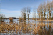
It's all downhill: at any point between Baumberg and Urdenbach, you have to descend a slope to enter the wetlands. At Baumberg this is no more than a gentle incline, but in Garath the Old Rhine dug itself a steep valley, and the houses of both Garath and Urdenbach are situated high above the wetlands. Whether gentle or steep, however, these slopes have the same origin: hundreds of years ago they formed the banks of the River Rhine. And they still function as riverbanks when the river reclaims the wetlands during a flood. At these times the Rhine washes its former shore, with Haus Bürgel forming an island in a sheet of water that extends all the way to the town of Zons.
This path follows the old shoreline and is very popular with local residents. It's good for running or cycling and also for walking dogs or just walking. As you go along, take a moment to look at the slope again and see it as the riverbank that, in a sense, it still is. Think of the forces the river can unleash. The gentle incline at Baumberg is a slip-off slope the inside bank of a curve in the river. The steep slope at Garath is its counterpart, the cut bank on the outside of the curve. This curve is clearly visible in the terrain as you follow the path.
If you drive around a bend in your car, you are pushed outwards. That's the way the River Rhine works, too. The pressure it exerts on the outside of a bend is much greater than that on the inside. While cutting the steep slope at Garath, the Rhine carried away countless lorryloads of material. For us humans, building a slope of this size and length would take a lot of work, even if we used excavators and not shovels.
Photo: Joschka Meiburgback